|
||||||||
| Hamilton Palace (site), Hamilton,
South Lanarkshire Hamilton and the Clyde valley |
||||||||
 |
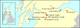
The site of what was once Scotland's largest and most magnificent country house, replete with the country's greatest-ever private collection of art treasures, is today occupied by a modern commercial retail park and road system dating from the 1990s, just to the west of the M74, Scotland's busiest motorway. The sheer contrast in style and setting between the palace complex which developed over the centuries and what now exists in Hamilton Low Parks could not be greater. This contrast provides a special challenge to re-create this one-time treasure-house and its parklands from old photographs, drawings and manuscripts, and especially from images of its priceless collections which have found their way around the world. This pair of maps shows, in the context of modern Hamilton and the complex configuration of roads in this part of the Clyde valley, the former location of Hamilton Palace and its many associated local properties. |
 |
||||||
|
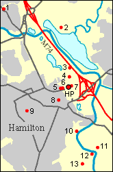
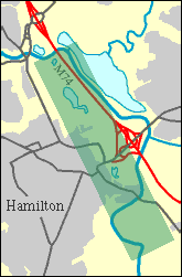
The site of the palace itself (HP) is at the centre of the map on the left, occupying a favoured position on the fertile river plain. On the right, the same map is used to show, against a modern background of roads and built-up areas, the strip which forms a simulated 'aerial' view of the estate landscape as it probably existed in the late 19th century. Reading from north to south on the left-hand map, the other buildings and monuments which have an association with the history of the palace, and which for the most part appear on this website, are as follows: 1. Bothwell Parish Church; 2. Hamilton Palace Colliery (site); 3. Nethertoun Motte; 4. Hamilton Mausoleum; 5. Hamilton Museum; 6. Riding School; 7. Collegiate Church (site); 8. Hamilton Old Parish Church; 9. Bent Cemetery; 10. Barncluith; 11. Châtelherault; 12. Cadzow Castle; and 13. Hamilton High Parks. |
||||||||
|
The maps above are reproduced from
Ordnance Survey material with the permission of Ordnance Survey
on behalf of the Controller of Her Majesty's Stationery Office ©
Crown copyright 2003. Any unauthorised reproduction infringes Crown
copyright and may lead to prosecution or civil proceedings. RCAHMS
GD03135G0011.2003
|
||||||||
|
|
|
|
|
|
|
|
|
|
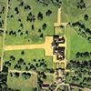 Detailed
view of the palace Detailed
view of the palace |
||||||||
|
|
|
|
|
|
|
|
|
|