|
||||||||
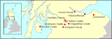
| Hamilton Palace (site) and Parks,
Hamilton, South Lanarkshire Virtual aerial view of landscape, 1896 |
||||||||
|
|
||||||||
 |
||||||||
|
© Fleming Woelfell
|
||||||||
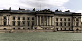
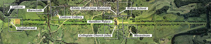
| Situated in the Low Parks in
the fertile valley of the River Clyde, Hamilton Palace stood at the
centre of an extensive garden which, as its main axis, had a great
north-south tree-lined avenue over 5km in overall length. This designed
landscape may have originated in the late 17th century but was first
drawn up in 1708 by Alexander Edward (1651-1708). The layout was later
developed, most notably by William Adam (1689-1748), who introduced
Châtelherault hunting lodge into the south avenue in the High
Parks where it commanded a broad vista northwards across the Low Parks.
This simulated 'aerial' view is a re-creation of the estate landscape as it probably existed in the late 19th century and is based on the 1:10,560 scale Ordnance Survey map of 1896. It takes as its centre line the great avenue which linked the palace (centre) with the High Parks and Châtelherault (left). To the right (north) of Châtelherault, it shows the avenue crossing the Avon Water on the line of the Old Avon Bridge. The northern section of the avenue runs past the mausoleum (bottom centre right) along what has then become a well-defined racecourse to a meander on the River Clyde (right) near Bothwellhaugh. With a group of 19th-century estate buildings on the site of the former 'Hietoun' immediately to the west (centre top) of the palace and a formal garden (top centre right), the palace and its immediate policies remained at this date screened from common view and insulated from physical encroachment by the neighbouring burgh of Hamilton (top centre). The burgeoning of industry in the locality is clearly represented by the former colliery at Cadzow (top centre left). [ The image is interactive - click on each site for further information. ] |
||||||||
|
|
|
|
|
|
|
|
|
|
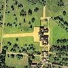 Detailed
view of the palace Detailed
view of the palace |
||||||||
|
|
|
|
|
|
|
|
|
|